


![]()


Local cycle routes lead through several parts of Bohumín. Most of the routes pass around the Aquacenter in Bohumín. The routes are marked with tables familiar to cyclists. Maps with cycling routes can be found on information boards in the terrain, in maps and promotional printed materials about Bohumín, which are available at information centers and also in the largest map server Mapy.cz (tourist map).
In the premises of the municipal company BOSPOR near the Aquacenter and the Sports Hall, cyclists can safely store their bicycles in cycloboxes . You can also find cycloboxes on the square in Staré Bohumín, near Kališov and Vrbicke jezera.
The longest eleven-kilometer route A ( mapy.cz/s/fazabapase ) connects to the Rychval cycle route to the Skučák pond, leads through the Březina forest in Záblatí past the well-known well, through the center of Záblatí past the chapel, along Anenská street past the statue of St. Anna and further along Rychvaldská to Skřečon, where it crosses the international cycle route No. 56 . It then crosses the Skrečoň flyover along Míru Street and after the Aquacentre continues along Koperníková Street and Šunychelská Street, where at the intersection with the U Zlatého jelena restaurant it crosses route 56 again and continues to Kališová Jezera.
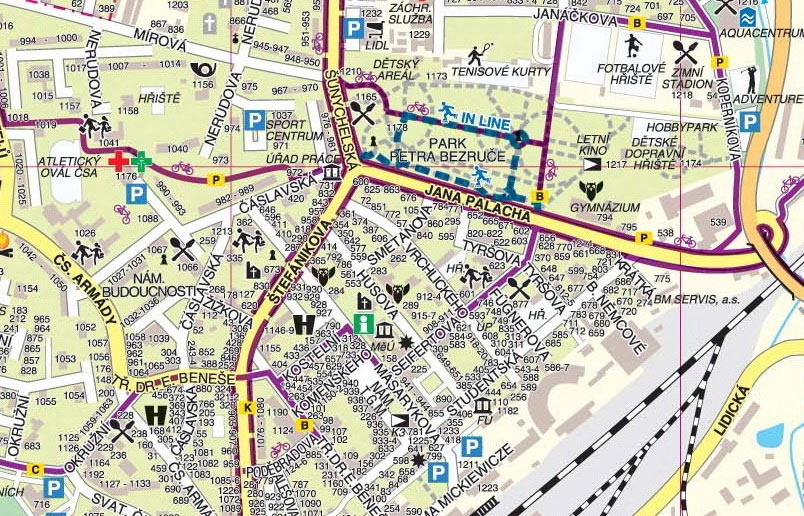
The eight-kilometer route B ( mapy.cz/s/novodojeca ) continues the route from the castle in Rychvald, leads around the Nový Stav pond, along Revoluční, Bezručová and Štefániková around the town hall, then along Seifertová through Petra Bezruč park and from the Aquacenter towards Nova Ves. where it again connects to route 56 .
The six-kilometer route C ( mapy.cz/s/nelotodeze ) leads cyclists from the center of Nové Bohumín along Na Chalupách Street to Antošovická lávka, along the Odra to the bridge over the Vrbicka stružka, along the cycle path on the embankment between Vrbicka lake and the Odra river to the highway bridge and the parking lot at Ostravská Street, where it connects to the E cycle route.
The three-kilometer route D ( mapy.cz/s/nonenegalu ) guides cyclists from the Polish border from Starobohumín Square past the Narození Panny Maria parish church on Ovocnou Street, where it connects to route 56 , leads past the Chapel of the Guardian Angels and at the intersection with Šunychelská Street along route A leads again to the premises of the BOSPOR company.
Cycle route E ( mapy.cz/s/damorubutu ) leads from Starobohumínská lávka (connects to cycle route P) along Ostravaská street through Pudlov and Vrbici towards Ostrava, where it connects to the Ostrava cycle route E.
Cycle route K ( mapy.cz/s/davorotede ) is called " Kopytovská" because it leads cyclists from the center of Nové Bohumín along the cycle path on Štefánikova and Šunychelská streets to Bohumín-Šunychl, past Kališova lake to the settlement of Kopytov. On its route, it passes detours to stops with information boards or rest stops built as part of the educational trail of the Odra border meanders natural monument.
The city route P ( mapy.cz/s/luvamozepu ) is marked according to Pustyňa chapel . The beginning of the markings is on Opletalová street in Nová Ves, where it connects to cycle route no. 56, leads cyclists through the Na Panském forest park to the Aquacentre, then past Petr Bezruč park, crosses route K via Štefánikova street and along the cycle path through the housing estate around the athletics stadium and Osvoboditelů street continues along P. Cingra Street towards Starý Bohumín. Via the rope bridge over the D1 highway, it leads to the cemetery in Staré Bohumín, where there is a turnoff to the Pustyňa chapel. Route P ends in Staré Bohumín at náměstí Svobody, where it is the junction of regional routes 56 ( mapy.cz/s/morecukaca ), 6257 ( mapy.cz/s/hucojetuha ), 10 ( mapy.cz/s/cocofetove ) and 6109 ( mapy.cz/s/mujurepova ), and where the local cycle route D also begins , which leads cyclists back to the Bohumín Aquacent via a different route via Bohumín-Šunychl along Ovocná Street.
Tourist attractions on local cycle routes
The column of the same name deals with all the interesting things in more detail .
Regional cycling routes
Long-distance route No. 56, which is 85 km long and leads to Bukovce, and regional route No. 6109 , which leads to Antošovická lávky and further along the left bank of the Odra along route G and upstream of the Odra river to the region, starts at the square in Staré Bohumín Sub-floor.
From Starý Bohumín, you can connect to Polish cycle routes. The EUROREGION 24C route and the EUROVELO R4 route begin beyond the border . These routes are followed by route 316Y of the Wodzisławski District and gmina Gorzyce, with a length of 52 km. The marked cycling routes R4, 9, 24, 39, 341, 347, 348 and 355 with a total length of 65.8 km lead through the most interesting terrains of the Krzyżanowice gmina.
Cycle route No. 6257 along the Odra and Olša rivers from Raciborze to Chotěbuzi is led from Starý Bohumín to Šunychlo along route No. 56 , the turn via Kopytov towards the Olša River is already under the designation of the entire route No. 6257 . In Nová Ves, the cycle route returns to route No. 56 via the underpass under the highway , from which it separates in Skřečon and continues under the sign 6257 towards Věřňovice and then further along Olš through Dětmarovice to Karvinou.
Trekkers and mountain bikes can use the road along the river Olše . From Staré Bohumín, there is a signposted cycle route No. 10 ( mapy.cz/s/cocofetove ), which leads through Šunychl to the confluence of the Odra and Olší rivers. across the Mlýnka stream, from where you can continue along route No. 6257 to Karviná - Darkova and on to the archeopark in Chotěbuza. Marked cycle route No. 10 then leads to Bukovce.
In 2016, the General cycle transport in the Karviná district region was prepared , which is a basic document for the coordination of the development of cycle transport both to work and for tourism.
Tips for cycling trips
If you love cycling trips and don't like to return along the same route, we offer several circuits around Bohumín and its surroundings. In the free time section, you can find tips for cycling trips .
Documents, tips, links
Map of cycling routes in Bohumín (2018) (jpg, 2 MB), page 2 (jpg, 1 MB)
Map of cycling routes in Bohumín and the surrounding area (2016) (jpg, 4 MB)
Cycling routes on the server www.cykloserver.cz
Map of cycling routes - Gorzyce (jpg)
Information board and map Bohumín - Dolní Lutyně (jpg)
Information board and map Dolní Lutyně - Karviná (jpg)
Information board and map Karviná - Chotěbuz (jpg)
Overview of cycle routes in the Czech Republic
Bike ride - Moravian Gate - Crossing routes and cultures (pdf, 2 MB)
Cyclists welcome portal
![]()